Finding the right kayak fish finder with GPS can dramatically improve your time on the water. The following selections combine sonar detail, GPS mapping or app integration, and portability suitable for kayaks and small boats. This guide covers five reputable options with solid performance, so you can compare features like beam width, depth range, and app compatibility before you buy.
| Product | Brand | Key GPS/Mapping Feature | Notes |
|---|---|---|---|
| Deeper PRO+ 2 | Deeper | GPS-enabled castable sonar with app sync | Wide, mid, and narrow beams; up to 100 m depth; portable |
| Deeper Pro Smart Sonar | Deeper | GPS mapping and bathymetric maps via app | Castable; 100 m range; two beam frequencies |
| Garmin STRIKER Plus 4 | Garmin | Built-in GPS and Quickdraw contours maps | Dual-beam transducer; 1-foot contours up to 2M acres |
| DANOPLUS Wireless Fish Finder | DANOPLUS | Real-time sonar data via handheld device | 147 ft depth detection; 90-degree cone; alarms |
| LUCKY Kayak Portable Fish Depth Finder | LUCKY | Handheld display with depth and fish indicators | 1–328 ft depth range; backlit display; portable |
Deeper PRO+ 2: Castable GPS Sonar
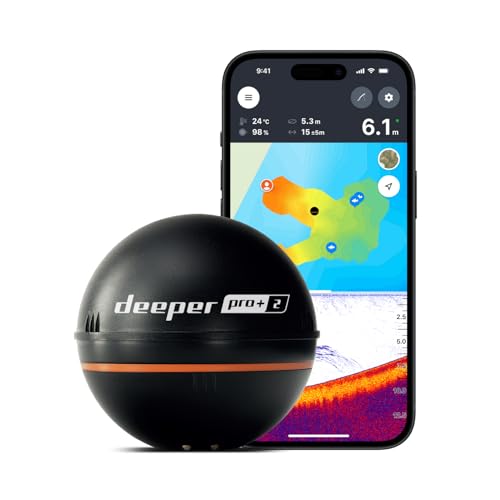
The Deeper PRO+ 2 combines a castable sonar with built-in Wi-Fi, enabling connection to the Deeper app for GPS-based mapping and location saving. It supports multiple beam configurations for wide area scanning or targeted depth checks, making it suitable for kayak anglers seeking precise target localization. Depth accuracy reaches up to 100 m, with a target separation as fine as 1 cm on narrow beams, which aids in pinpointing small or closely spaced targets. The device is designed for use on kayaks, boats, and ice fishing, offering a flexible solution for various fishing environments.
Deeper Pro Smart Sonar: GPS Castable

The Deeper Pro Smart Sonar offers real-time data with two beam frequencies and 15 scans per second, enabling quick data capture for depth, bottom structure, vegetation, and fish. GPS mapping capabilities let users generate bathymetric maps from boats, canoes, kayaks, or belly boats and store scans, points of interest, and notes within the Fish Deeper app. Compatibility with iOS and Android devices provides a familiar user experience for smartphone users, and the device’s 80 m depth range covers many freshwater and coastal scenarios.
Garmin STRIKER Plus 4: Built‑in GPS

Garmin STRIKER Plus 4 combines CHIRP sonar with a built-in GPS and Quickdraw Contours mapping software. The dual-beam transducer provides clear target separation, while the Quickdraw contours feature enables the angler to create and store detailed maps with 1-foot contours across substantial areas, up to 2 million acres. Mark waypoints, build routes, and monitor boat speed directly on the device, making it a strong all-in-one option for kayaks that require reliable navigation alongside fish finding.
DANOPLUS Wireless Fish Finder

This wireless handheld fish finder covers a broad depth range to 147 feet (45 m) and uses a 90-degree detection angle to scan under the kayak or boat. The display shows depth, water temperature, fish size icons, and the presence of bottom features like vegetation or rocks. An audible fish alarm enhances late-afternoon or murky-water fishing by alerting the angler to fish activity in the transducer’s coverage area. It’s suitable for kayaks where a compact, portable sonar is preferred.
LUCKY Kayak Portable Fish Depth Finder
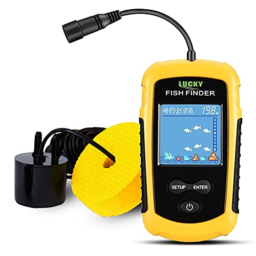
The LUCKY handheld unit provides a portable solution for kayak anglers, displaying approximate fish locations and water depth on a backlit LCD. It supports a depth range from 3 ft (1 m) to 328 ft (100 m) and lets users switch between metric and imperial units. The device is designed for one-handed use and includes a neck strap for hands-free carrying while fishing, with five sensitivity levels to adapt to different water conditions. It is a practical option for casual kayak fishing where GPS mapping isn’t strictly necessary but quick depth awareness matters.
Buying Guide: Key Purchase Considerations
- GPS and mapping capabilities: If GPS tracking and bathymetric mapping are essential, prefer castable units with app-based maps (Deeper PRO+ 2, Deeper Pro Smart) or devices with built-in mapping (Garmin STRIKER Plus 4).
- Depth range and beam configuration: Wider beams cover more water, while narrow beams provide higher target resolution. Depth ranges up to 100 m or more suit deep lakes and tidal estuaries.
- Portability and mounting: For kayaks, compact, lightweight units or handheld devices minimize drag and complexity. Some products are designed specifically for mounting on kayak transoms or rails, such as multi-brand mounts.
- App ecosystem and data access: Consider how maps, scans, and waypoints are stored and shared. Some Deeper devices save scans automatically in an accompanying app; Garmin devices rely on Quickdraw maps and GPS data within the unit.
- Power and reliability: Castable sonar units use their own battery or smartphone power when connected via Wi-Fi. Check battery life and charging options for longer sessions on the water.
- Durability and water resistance: Saltwater and freshwater applications benefit from IP ratings and rugged construction. IP68-rated devices perform better in rough or icy conditions.
- Ease of use: Quick setup and intuitive interfaces help beginners, while advanced anglers may prefer devices with more customizable mapping and waypoint features.
- Price vs value: While premium models offer GPS mapping and higher precision, affordable handheld options still provide essential depth and fish detection for recreational kayaking.