Choosing the right GPS device for walking involves balancing screen clarity, battery life, multisensor navigation, and rugged durability. The following selections combine rugged handhelds and smartwatches from trusted brands, designed to help hikers and walkers navigate with confidence across the UK’s varied terrains. Below you’ll find five top options, each with key features to match different needs—from long expeditions in remote landscapes to daily fitness tracking on urban routes.
| Product | Type | Key Strength |
|---|---|---|
| Garmin eTrex SE | Handheld GPS | Ultra-long battery life in expedition mode |
| Garmin eTrex 32x | Handheld GPS | Topographic maps and multi-satellite support |
| Garmin GPSMAP 65s | Handheld GPS | Expanded GNSS with dual-band and compass |
| SUUNTO Vertical | GPS Sports Watch | Dual-band GNSS with long battery life |
| COOSPO CS600 | Bike Computer / GPS | 2.4″ color touchscreen with route navigation |
Garmin Etrex SE – Rugged Entry

The Garmin eTrex SE is a rugged, easy-to-use GPS handheld offering essential navigation features for walkers. Its 2.2” high-resolution display remains legible in bright sunlight, helping you read maps and waypoints on the move. A standout benefit is the long battery life, delivering up to 168 hours in standard mode and up to 1,800 hours in expedition mode with two field-replaceable AA batteries (not included). This makes it suitable for longer UK hikes where recharging options are limited. The device is designed to withstand outdoor conditions while providing straightforward waypoint management, track logging, and basic compass functions for reliable navigation in mixed terrains.
Features at a glance: rugged build, intuitive interface, bright display, and extended operational life. For walkers who prioritise endurance and simplicity over advanced mapping, the eTrex SE offers dependable performance with minimal fuss.
Garmin Etrex 32x – Durable Mapping Companion
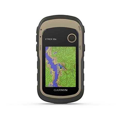
The Garmin eTrex 32x expands capabilities for walkers who demand richer geographic data. It comes with a 2.2-inch sunlight-readable colour display and preloaded topoactive maps with routable roads and trails, useful for both cycling and hiking. Its support for GPS and GLONASS satellites improves tracking in challenging environments where GPS alone may struggle. Notable features include a built-in 3-axis compass and a barometric altimeter to help with orientation on climbs and descents. With rugged construction and reliable satellite reception, the eTrex 32x is well-suited for UK hill country where weather and terrain can be variable.
In practice, this model provides a stronger combination of mapping detail and sensor data for walkers who want dependable navigation across forests, moorland, and coastal routes, alongside robust navigation in urban landscapes with multi-satellite precision.
Garmin Tread 2 – Overland Edition

The Garmin Tread 2 offers an 8-inch ultrabright touchscreen designed for extreme weather and temperatures, with glove-friendly operation. While marketed as an overland navigation device for off-road expeditions, its large display and turn-by-turn trail navigation support dense trail systems and open roads alike. It includes preloaded topographic maps for multiple regions and City Navigator maps with custom routing in several areas. Built to tolerate harsh environments (IP67 rating), it is a capable navigational hub for walkers who often venture off the beaten path and need dependable guidance in remote or exposed locations. Always cross-check road signs and conditions when driving or traversing mixed terrains.
Example use cases include off-road day hikes, long backpacking trips, and scenarios where a larger display and advanced routing help in challenging landscapes across Europe, Africa, and the Middle East.
Garmin GPSMAP 65s – Multi-band Navigation
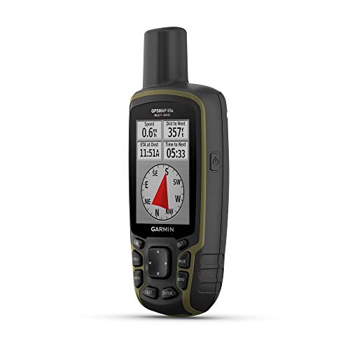
The Garmin GPSMAP 65s is a button-operated handheld with an altimeter and compass, designed for expanded satellite support and multi-band technology. This helps maintain signal accuracy in demanding environments, such as canyons, urban areas with tall buildings, or dense forests. It includes routable TopoActive mapping and a federal public land map (U.S. only). The 65s is engineered for walkers who require dependable, high-precision navigation over long distances and varied topographies. The combination of robust GNSS support and accessible mapping makes it a strong choice for serious walkers who also track elevation profiles and routes.
SUUNTO Vertical – Dual-GNSS Smartwatch

The SUUNTO Vertical GPS sports watch provides dual-band GNSS tracking, combining GPS with GLONASS, GALILEO, QZSS, and BEIDOU for precise tracking in complex terrains. It offers offline maps and breadcrumb navigation for reliable outdoor navigation, paired with a long battery life—up to 60 days in daily use and 60 hours in Performance mode, with the solar variant adding another 30% under bright exposure. The watch supports multiple sports profiles and advanced health and recovery analytics, making it suitable for walkers who want ongoing physiological insights in addition to navigation. The compact wearable form factor ensures it stays on the wrist during long day hikes and challenging routes.
Garmin Vivoactive 6 – Fitness Smartwatch

The Garmin Vivoactive 6 combines fitness tracking with GPS smartwatch functionality, featuring an AMOLED display and up to 11 days of battery life. It includes 80+ sports apps and guided workouts, making it a strong choice for walkers who want daily activity tracking, training guidance, and recovery insights in a smartwatch form. The bundled components provide added value for those seeking a complete wearable package for fitness and navigation on the go.
COOSPO CS600 – 2.4″ GPS Bike Computer

The COOSPO CS600 offers a 2.4″ high-resolution color touchscreen with auto-backlight for outdoor readability. It uses precise GPS tracking with GLONASS and offers route navigation, breadcrumb trails, and backlight-adjusted visuals ideal for walking in varied light conditions. While primarily positioned as a bike computer, the device’s navigation features are adaptable for walkers needing clear route guidance on mixed terrain. The device supports Bluetooth/ANT+ connectivity and provides a backlit display for day-to-night navigation across UK routes.
Buying Guide: Key Considerations For Your Walks
When selecting a GPS device for walking in the UK, consider these factors:
- Display readability: Screens that remain legible in bright sun and low light help reduce eye strain on long walks.
- Battery life: Longer life in standard or expedition modes reduces the risk of losing navigation on remote trails.
- Navigation features: Look for topo maps, routable roads and trails, breadcrumb routing, and offline maps for areas with poor signal.
- Sensor suite: A built-in compass, barometric altimeter, and multi-band GNSS improve accuracy in difficult terrain.
- Durability: A rugged build and weather resistance are essential for UK weather variability.
- Form factor: Handheld units suit long hikes with map details; smartwatches offer continuous activity tracking with easier wearability.
- Maps and data: Preloaded topo or public land maps add context for planning routes and understanding terrain.
- Battery charging options: Interchangeable batteries or long-lasting rechargeable packs can be a decisive factor for extended trips.
How to compare models for a given trip: if you prioritise endurance for multi-day excursions, a handheld unit with expedition-level battery life, robust build, and clear topographic mapping is ideal. For day hikes and urban walks, a compact smartwatch with dual-band GNSS and offline maps balances navigation with wellness features. Consider the terrain type, typical weather, and your preferred balance between screen size, battery life, and data depth. Cross-check user reviews and firmware support to ensure ongoing map updates and reliable satellite performance in your usual walking environments.